- Home
Welcome !
CAPITELCO is a fully owned Bahraini company that is involved in all aspects of Surveying and Postioning with satisfied clients spread all over the Gulf Kingdom.
Capitelco is a leading provider of advanced positioning solutions that maximize productivity and enhance profitability.
- Business Sector
- Product
Product Category
GIS & Survey
Constructions
Marine
Services
- Contact Us
Ready To Call Us
Manama: Head Office
Flat 56 Building 962 Road 1812 Block 318,
Hoora,
Kingdom of Bahrain.
Tel: +973 17 340 301
Fax: +973 17 340 302


|
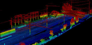
Mobile Mapping Mobile mapping is the process of collecting geospatial data from a mobile vehicle, typically fitted with a range of photographic, radar, laser, LiDAR or any number of remote sensing systems. Such systems are composed of an integrated array of time synchronised navigation sensors and imaging sensors mounted on a mobile platform. The primary output from such systems include GIS data, digital maps, and georeferenced images and video. | |||
|


CAPITELCO | TEL 00 973 1734 0301 FAX 00 00 973 1734 0301